The desert looks almost peaceful from way up in the air over the Red Sea coast. The beige dunes look like waves, and the only things that break them up are the thin scratches of construction roads and the shiny metal of machines baking in the hot sun. Then the satellite pictures finish loading on the screen, and the quiet illusion breaks. NEOM, which is supposed to be Saudi Arabia’s $2 trillion “city of the future,” is mostly known for its flagship project. The Line doesn’t look like a shiny city miracle; instead, it looks like raw scars in the sand, half-built buildings, dust storms caught in the middle of their sweep, and lonely worker camps strung along a straight cut through nowhere.
You can zoom in on a dream that was sold as perfect, one pixel at a time.
From up here, in orbit, the advertising fades away. Something more real comes through.

From shiny pictures to dusty reality
If you search for “NEOM The Line” on YouTube or X, you’ll find a lot of smooth animations. A mirrored wall that is 170 kilometers long, trains that float, lush vertical gardens, and sunlight bouncing off glass like in a sci-fi movie. After that, you open new satellite images on Google Earth, Maxar, or Sentinel, and the mood changes quickly. Instead of a finished “zero-carbon paradise,” you see a trench cut through the desert, groups of cranes, and gray smudges where mountains have been cut open.

It doesn’t look clean at all.
It looks like surgery on a living landscape, with the patient still bleeding sand.
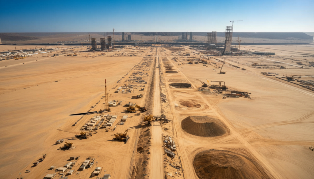
The Line doesn’t look like a city at all in recent high-resolution photos. It looks like a construction front that goes on forever: a narrow corridor, about 200 meters wide, pulled in a straight line toward the horizon. You can see worker housing blocks next to graded roads, material yards full of concrete pieces, and huge terraced cuts where rock has been broken up to make room for the foundations.
When you zoom in more, you see something else: pads that look like they’ve been left behind and places where work seems to have stopped, like a video that someone paused months ago. Parts of the desert look strangely quiet for a $2 trillion vision.
There is more to the gap between the renders and the pixels than just looks. It tells a story about size, danger, and time. Satellite images don’t make fun of the goal; they show the physics. Moving that much dirt, directing that much water, and keeping that many people alive in one of the harshest climates on Earth is not a movie montage. It’s a war of logistics.
*From space, you can see how tired the temporary camps are, how long the shuttle roads are, and how the quarries fan out like spider legs from the main trench.*
When the drone batteries die and the PR teams go home, this is what “the future of urban living” looks like.
The slow truth that was written in sand
If you want to know what NEOM really means, stop listening to the speeches and start keeping an eye on the desert over time. Historical images from Google Earth’s satellite platform, Sentinel Hub, and paid services like Planet Labs give a rough but useful timeline. If you go back to 2018, the area is mostly the same. The scars get worse as the years go by. Roads look like veins. The sand gets darker when there are quarry pits. Long, straight trenches run west from the Gulf of Aqaba.
You don’t see a city appear when you watch it frame by frame. You can see a supply chain getting to work.
“Construction footprints” aren’t something we think about very often. We respond to viral videos like robot maids, flying taxis, and desert ski slopes. But satellite passes don’t care about what’s popular. They keep track of things like how many kilometers of trench were added this season, how many new worker dorms were built, and how long a section stays untouched. Analysts have already seen signs that some parts of The Line’s 170 kilometers, which were originally hyped, may be cut back for 2030. The pictures suggest a change in strategy: focus on a shorter first segment, hope it impresses, and worry about the rest later.
Let’s be honest: when the render video looks cooler, no one really reads the masterplan PDF.
This is where the politics and the simple physics meet. Every new satellite photo is a reality check on the original promise of a fully working linear city by 2030. The trailers for the “mirror wall in the sand” movie made the ground story seem slower, messier, and much more limited than it actually is. The on-screen ruler function lets you measure the distance between the dream and the trench.
Saudi Arabia isn’t the first country to make a mega-vision bigger, and it won’t be the last. But the desert makes it very clear that they are lying. The bulldozers can’t hide anywhere.

You don’t just see a megaproject from above. You can see a deadline running out of time.
What the satellite pictures quietly show
When researchers, investors, and even regular people want to cut through the hype, they use a trick: they pick three or four “checkpoints” that show up again and again in satellite views and only watch those over time. For NEOM and The Line, that could be the western coastal hub, a central trench, the eastern end near Tabuk, and one or two big quarry areas. Then, every few months, they take new pictures, zoom in on the same spots, and ask, “What has really changed?”
It sounds almost too easy. That’s how it works.
You quickly learn the difference between “staging” and “progress” when you do this. Are ships lined up at a new port? That’s real throughput. A growing grid of places for workers to live and park their buses? Real work on the ground. A single showpiece building in the middle of miles of nothing? In 3D, that’s a billboard. A lot of people are scared of “geospatial analysis,” but you don’t have to be an expert to see when new paved roads stop going on or when a quarry’s growth plateaus.
We’ve all been there: when the numbers or pictures quietly tell you that the story doesn’t match the sales pitch.
The more you look, the more the pattern around NEOM seems like it could be anywhere. Grand ideas racing against money, time, and the laws of physics. People came to work, mountains were cut open, and then the slow, grinding question: will enough people really want to live here full-time, without the filters and ads? Critics, former workers, and environmental groups have begun to express doubts, and these orbital snapshots now show that they are not alone in their doubts.
A European city planner told me, “You can’t see the marketing from the sky.” “You see land use, intensity, and momentum.” NEOM looks busy in some places, but it doesn’t look like a city is being built. It feels more like an experiment, and I’m still not sure what it is.
- Don’t just look at the renders; compare the promotional images to real photos taken from space or on the ground.
- Use historical imagery tools to see if work is speeding up or slowing down over time.
- Keep an eye on the support systems. Ports, roads, housing, and utilities can tell you more than famous buildings.
- Listen for silence: When official updates slow down and satellites show no movement, that gap is important.
- Keep in mind the simple truth: it’s easy to draw big dreams, but it’s very hard to make them real.
A mirror for our own desire for entertainment
The story of Saudi Arabia’s megacity in the desert isn’t just a Saudi story. It’s also about how much we love to see things and how ready we are to click, like, and share futuristic fantasies long before they happen. NEOM went viral because it promised everything at once: no cars, no streets, a perfect climate, clean energy, and glass walls that went all the way to the sky. A Dubai 2.0 that doesn’t make you feel bad, powered by algorithms and solar panels instead of traffic jams and air conditioning. People wanted it to be true.
Satellite images don’t make fun of that wish. They quietly point out the difference between wanting and building.
Looking at these pictures from space, you can feel two truths clash. On one side, there’s a country that wants to get away from oil dependence but is scared of being left behind in a world after fossil fuels. On the other hand, a fragile desert ecosystem is being ripped apart for a bet that people will be happy to live in a 170-kilometer corridor. People said that The Line would change city life forever. From space, it looks like a bunch of hard questions were poured into concrete.
What if the excitement dies down before the city is full? What happens to the sand that has already been moved?
None of this means that NEOM is doomed or that having goals is bad. It means that reality is loud, and satellites have made it even louder. Governments can still dream, companies can still pitch, and architects can still draw impossible skylines. But anyone with access to the internet can now open a browser and quietly ask, “Okay, but what’s going on today?”
The desert never forgets the lines we draw on it. The next time you see a trillion-dollar city in your feed, you might want to take a quick trip into orbit and let the sand do the talking.

| Key point | Detail | Value for the reader |
|---|---|---|
| Satellite images strip away the PR | They reveal trenches, worker camps, and quarries instead of finished “mirrored cities” | Helps you judge what’s real progress versus marketing promises |
| Time-lapse views tell the real progress story | Historical imagery shows whether construction is accelerating, stalling, or shrinking in scope | Gives you a practical way to track megaprojects on your own |
| Hype vs. physics is a universal tension | NEOM highlights how grand visions collide with desert conditions, money, and human behavior | Invites you to be more critical and curious about every “city of the future” you see online |
Questions and Answers:
Question 1What do the most recent satellite pictures of NEOM’s The Line site show?
They show a long trench, road networks, several construction zones, clusters of worker housing, and quarries. However, only small parts look like a finished city.
Question 2: Is Saudi Arabia still building the whole 170 km of The Line?
The vision is still there, but pictures and recent reports suggest that the first built phase may only cover a small part of the whole thing, with the rest pushed back to an unknown date.
Question 3: Is it possible for anyone to use satellite tools to check on NEOM’s progress?
Yes. You can look at the area, compare dates, and see how the landscape has changed over time on free sites like Google Earth and Sentinel Hub.
Question 4: Do the pictures show that NEOM is failing?
No. They don’t show the whole picture of the economy or politics. They just show that the real world is a lot different from the polished, finished renders.
Question 5: Why is satellite evidence important for a project like this?
Because it gives people, investors, and researchers an independent, almost real-time way to check public claims, which helps them ground the story in facts that can be seen.